Last Updated on: 2nd October 2024, 03:45 pm
Despite being one of Central Mexico’s most popular day treks, hiking La Malinche volcano may not be for everyone. At 4,461 m above sea level, it’s the 6th-highest peak in Mexico. And the hike to the summit is steep and difficult. But those who are up for the challenge will be rewarded with some of the region’s most spectacular views.
Climbing La Malinche can be done as a day trip from Puebla, though staying in a cabin at the base is also an option. In the following guide, we’ll be covering what to expect from the hike itself along with a detailed rundown of how to get there.
About This Hike
THE BASICS: Hiking La Malinche can be quite challenging, and not everyone succeeds in making it to the top. It is, at least, a very straightforward hike, and you’re unlikely to get lost.
The hike is also not terribly long. The roundtrip journey is about 12 km and involves an elevation gain of 1,275 m. If you maintain a steady pace, you should be able to complete it in about seven hours (four up and three down).
Note that if you are hiking La Malinche as a day trip from Puebla, you must complete the hike in under eight hours to catch the return bus (more on logistics below).
WHAT TO BRING: Good shoes are essential – either hiking boots or trailrunners. Trekking poles are also a good idea if you have them.
I brought two of them, but lent one to another hiker I met on the trail. I found that one pole was actually ideal, as it was helpful to have a free hand while scrambling up the rocky portions.
Of course, as with any strenuous hike, you’ll want to bring plenty of snacks, water, sunscreen and a hat. Also come prepared with long sleeves (more than one layer if possible), as it can be quite cold on the mountain throughout the year.
OTHER TIPS:
- At 4,461 m above sea level, La Malinche’s altitude is no joke. Even if you don’t normally eat them, high-carb snacks are said to help with the light-headedness you might experience at high altitudes.
- If at all possible, try to hike on a day with a forecast of almost zero precipitation. The last thing you want to deal with during an already difficult hike is high winds, fog and rain.
- La Malinche is arguably one of Mexico’s most popular hikes, and things can get packed on the weekends. If possible, try going on a weekday instead.

RECOMMENDED APPS: The trek to the top is clearly and accurately outlined on the Maps.me app, a free app which works offline.
You can also use AllTrails or onX Backcountry, though one must pay to use them offline.
Hiking La Malinche
Arriving at the campground from Apizaco (more below), it takes just a few minutes to walk to the trailhead. Given the timetable of the bus route, you should be starting your hike just after 9:00.


The beginning of the hike is relatively uneventful, as you’ll simply be walking through a forest for a couple of hours. While not terribly steep, it is indeed an uphill climb, and you may soon start to find yourself unexpectedly tired.
This is due to the altitude, as it won’t be long before you exceed 3,000 meters above sea level. While altitude sickness affects each person differently, it partly depends on how long you’ve spent in Puebla or Mexico City (both above 2,000 m) prior to the hike.


In my case, I’d just arrived in Puebla a couple of days prior, and I was experiencing shortness of breath much sooner than I normally would on a hike. But my body gradually acclimatized over time (at least until the end).
Exiting the forest, you should make it to the tree line around 11:00.

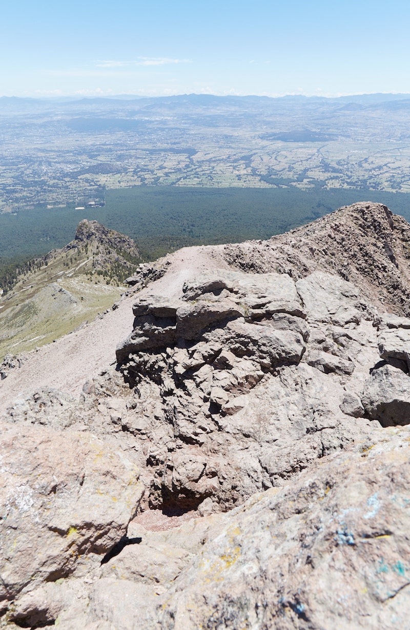
From here on, the hike gets a lot more challenging, but the views will grow increasingly more impressive. You’ll next have to traverse through a grassy meadow area, and the trail will gradually become less distinct.

From here you can already see the ‘false peak’ of La Malinche, and that’s obviously where you’ll want to head. As mentioned, hiking La Malinche is by no means easy, but the route is at least refreshingly straightforward.
There is one section, however, where you’ll find yourself needing to make a choice. As you approach the grassy ridge on your right, one option is to hike up it and then along it.
Another option is to avoid the ridge and head left, eventually taking a steep, sandy path up toward the false peak.
But which one should you choose? I’d definitely recommend heading toward the right and walking along the ridge. You can then take the slippery, steep path on the way down.
The steep path has so much loose sand and gravel that it would be like hiking up a really steep sand dune.


At the tree line, I’d exchanged greetings with a group of Mexican hikers who were hiking La Malinche with a guide. But I never ran into them again until I was back in the forest on the way down.
It turns out that they tried to go up via the steep path, but ultimately failed and gave up. (So much for hiring a guide!)


The higher you go, the more beautiful the views of your surroundings will become. Provided the weather is clear, look around you and you’ll be able to see the mountains of Popocatépetl, Iztlazihuatl and Pico de Orizaba, Mexico’s highest peak.
Some hikers, in fact, use La Malinche as a warm up for one of those more difficult hikes.


But as hiking La Malinche became more and more strenuous, ascending an even higher mountain was the last thing on my mind!
Eventually, any semblance of a trail disappeared yet again, and I found myself walking over nothing but volcanic rock.


It was here around the rockiest and steepest section that the altitude sickness began kicking in again. At over 4,000 meters above sea level, I found myself lightheaded and somewhat disoriented – surely not the best state to be in on such terrain.
I took a break on the rocks for a bit, eating some of the sweet snacks I’d brought for the trip. Sweetened dark chocolate seemed to do the trick, and after several minutes, I was ready to continue.

As mentioned above, I’d lent one of my trekking poles to another hiker I’d met on the trail, and with whom I’d end up hiking to the peak. And it was nice to have a free hand here, as the final portion of hiking La Malinche is indeed a scramble.

The higher we went, the more false peaks we encountered. Just as we were sure we were just about there, we’d soon discover we still had a while to go.
We were, at least, relieved to find ourselves on semi-flat ground again as we walked toward what we hoped was the real peak.
Interestingly, despite running into several other hikers on the way up, we found ourselves completely alone for this final portion of the hike.


Turning around, we were greeted with even more stunning views of Tlaxcala and Puebla and their many mountains. The tree line we’d just walked through a few hours prior, meanwhile, seemed like a world away.

Finally, after some more steep and rather slippery climbing, what was undoubtedly the real summit came into view in the distance. But we still had one more challenge in store before we could conquer La Malinche.

The final climb up the craggy rocks which constitute the peak was the toughest scramble yet, but we finally made it to the top at around 13:00 in the afternoon.
We sat down on the cold and windy peak and indulged in whatever food we had left in our backpacks. With no flat surface at the top, it wasn’t the most comfortable way to celebrate, but we were elated that we’d made it.

Who Was La Malinche?
Sometime in the 17th century, the volcano took on its current moniker, La Malinche, after one of Mexican history’s most controversial figures.
Born around the year 1500, La Malinche was a native Nahua woman who was sold as a slave to Spanish conquistador Hernán Cortés.
She would go on to serve as his translator and advisor, and Cortés would also choose her as his consort. Fluent in Nahuatl, Chontal Maya and eventually Spanish, La Malinche played a pivotal role in the conquest of Mexico.
Thanks to her language skills, the Spaniards managed to communicate with the Totonacs of Veracruz, who were eager to defeat the Aztecs at any cost.
The joint Spaniard, Totonac and Tlaxcalteca army would eventually go on to defeat the Aztecs, and Mesoamerica would never be the same again.
Ever since, La Malinche has largely been regarded historically as a traitor. While some argue that she had no choice, when given the option, she did indeed side with the Spaniards over the natives during the Cholula Massacre.
With that being said, native groups like the Totonacs and Tlaxcalans played a major role in the conquest as well, as they were fed up with the Aztecs’ brutality. Clearly, the situation was a lot more nuanced than modern Mexican society likes to portray it.
Considering how what we now know as Mexico is a blend of both native and Spanish cultures, La Malinche is also recognized by some as a founding figure of the country.
Aside from its association with La Malinche, the volcano also has its own mythological origin story. It involves a woman named Matlalcueye, who was engaged to a warrior named Cuatlapanga.
When Cuatlapanga didn’t return from battle, Matlalcueye died of a broken heart. But Cuatlapanga was indeed alive, and he eventually returned home to hear the bad news. Cuatlapanga himself would die and turn into a small mountain of the same name.
And Matlalcueye turned into the peak we know as La Malinche today. The natives of this region, in fact, long referred to the mountain as Matlalcueitl.


Though it would’ve been nice to linger for a bit longer, we’d still have a return bus to catch, and I didn’t want to have to worry about the time while making the descent. But first, we had to get down from the rocky peak.
The way we’d scrambled up, it turned out, was too steep to get back down, and we had to search for an alternative. Luckily, we found a way with a bit of trial and error, but this was arguably the most nerve-racking part of the entire hike.


On the way back, we headed down the steep sandy path we’d ignored on the way up. Rather than taking regular steps, it was often better to just let the heels of our feet glide down the sand.
I’ve never been a fan of steep descents on hikes, and my knees were certainly glad I had a trekking pole.

We made it back to the base just before 16:30, and the bus to Apizaco arrived right on time at 17:00.
I could hardly keep my eyes open for the return journey to Puebla, and it was already after dark by the time I made it to my accommodation.
After a quick shower, I fell right asleep. Realizing that the following day would be the only other day during my stay with a 0% chance of rain, I woke up early again for yet another hiking adventure: Mt. Tlaloc.
Additional Info
Hiking La Malinche as a day trip from Puebla involves one transfer, while you’ll also have to get up extra early.
First, you’ll need to arrive at Puebla’s main bus station, CAPU, from where you need to take the 6:00 bus to the town of Apizaco in the state of Tlaxcala. The buses are run by a company called ATAH.
The journey on this Ejecutivo class bus takes about an hour, so you’ll have a bit of time to kill when you arrive in Apizaco. But at the time of writing, the next bus doesn’t depart until 7:30, so taking the first bus of the day is a must.
There is also a cheaper ordinary class of bus that departs every 12 minutes from 5:00 in the morning. Understand, however, that these buses will take at least 90 minutes, so it’s probably safer and simpler to take the 6:00 Ejecutivo bus. You can find the most recent ATAH timetables here (be prepared to scroll down a lot).
(Confusingly, when you arrive at CAPU, you’ll likely find the ticket counter for ATAH empty. Don’t worry, though, as you can find a ticket vendor just next to the actual gate.)
While it will be tempting to sleep on the early morning bus ride, don’t miss the beautiful view of the sunrise over the peak of La Malinche from the window.
Arriving in Apizaco, the first thing you’ll notice is how cold it is so early in the morning! (Another reason to bring some warm clothing.) From the ATAH station, you’ll need to walk toward the Mega Elektra store on Calle Aquiles Serdan. The walk should take less than ten minutes.
On this street, you’ll find loads of minivans heading to towns all over the region. You’ll need to catch a minivan bound for the Malintzi Resort which departs around 8:20. It’s imperative that you make this bus.
Otherwise, you won’t have enough time to do the hike and make it back to Puebla on the same day. (You do have the option, however, to stay in a cabin at the base of the mountain.)
With so many different minivans around here, it can be confusing to know where to stand. The best idea is to simply ask someone. Once in the van, the ride takes about 40 minutes, and you’ll arrive at the trailhead just after nine.
When finished with your hike, return to the same spot where you got dropped off to catch the 17:00 return bus. Returning to Puebla, you have the choice between either the Ejecutivo or ordinary class ATAH buses, which actually depart from different stations. Both should be marked on Google Maps and Maps.me.
The most beautiful part of Puebla is undoubtedly its Centro Historico. And this is also where you’re going to find most of the city’s cultural landmarks. What’s more, is that there are plenty of hotel options to choose from here, such as the highly-rated Hotel Boutique Casareyna (high-end), Hotel Diana (midrange) and Hotel Centro Historico (budget).
But would there any reason to not stay in the center? Yes, and for two main reasons. First of all, Puebla is not just a destination in its own right, but the city is one of the best bases for day trips in all of Mexico.
Secondly, the main bus station, CAPU, is unfortunately located quite far from the center. While I originally wanted to stay in the historical district, I realized that there were at least five day trips I wanted to go on that would require a visit to CAPU – not to mention my arrival and departure days.
And so I found an Airbnb within fifteen minutes on foot from the station. In the end, I’m really glad that I did, as it saved me a lot of time and hassle.
Unfortunately, however, the whole area around the bus station is not the most charming, to say the least (though it did at least feel safe). Compared with the historical center, it felt like another world.
While I didn’t have the best experience at my Airbnb for various reasons, you may want to consider Hotel Central, located right next to the station. I would end up staying here during a later trip, and while it was very basic and a bit rundown, I found it fine overall for the price.
Puebla has no tram network, and the drive between the center and CAPU is at least 20 minutes (only if traffic is perfectly smooth). Deciding where to stay, then, all depends on how many day trips you’ll be taking and how extra early you’d be willing to depart to ensure you don’t miss your buses.

Pin It!