Last Updated on: 14th August 2025, 08:03 am
The Caprock Coulee Trail is Theodore Roosevelt National Park’s flagship hike. Though I didn’t embark on it with any special expectations, its ever-changing scenery continued to amaze me throughout, and I’d even go as far as calling it one of my all-time favorite hikes.
Not only is it arguably the best hike in the Dakotas (just edging out Custer State Park’s Black Elk Peak loop), but it surely ranks up there with some of the most scenic hikes in the entire country. With that said, it’s not particularly well-known, and you’re unlikely to encounter many other hikers.
In the following guide, we’ll cover everything you need to know about the Caprock Coulee Trail and what makes it so special. For more general info on Theodore Roosevelt National Park, be sure to check the end of the article.
About This Hike
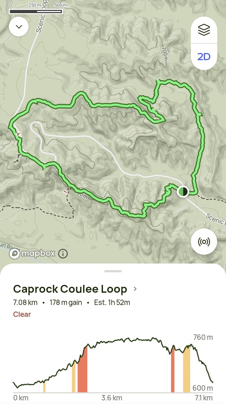
THE BASICS: The Caprock Coulee Trail is a 4.1 miles (6.6 km) loop hike. With an elevation gain of 584 feet (178 m), it could be considered moderate in difficulty. Expect it to take you about 2-3 hours. In my case, I finished it in two hours and fifteen minutes.
At about halfway through the hike, you’ll arrive at the River Bend Overlook which is also accessible via the North Unit’s main road, Scenic Drive. But it’s certainly more satisfying to hike up to rather than simply reaching it by car.
Note that the trailhead for Caprock Coulee is right next to the Prairie Dog Town via the Buckhorn Trail hike. You can do the two hikes back-to-back, taking a break at your car in between.
By accessing the trailhead right next to the parking lot, you’ll be hiking the loop trail counterclockwise, which is how we’ll be detailing the hike below.
WHAT TO BRING: As this isn’t a terribly long or difficult hike, you only need to worry about basic items like water, a hat and sunscreen. Sturdy hiking shoes would be ideal but a trekking pole isn’t necessary.
In general at Theodore Roosevelt National Park, it’s a good idea to wear long hiking pants. While I didn’t encounter any bison on this particular hike, it’s not uncommon to have to take detours through tall grass or thick overgrowth when a bison is blocking the trail.
RECOMMENDED APPS: The on-site trail signage is pretty helpful, but it’s always good to have the help of an app. You can find the full trail outlined on AllTrails or OnX Backcountry, though you’ll have to pay for a yearly subscription in order to download it and access it offline. Otherwise, the free Organic Maps app should come in handy.
Hiking the Caprock Coulee Trail
The trailhead for Caprock Coulee is about exactly halfway down the North Unit’s main road, Scenic Drive. If you arrive early enough, you should have plenty of time for all of the North Unit’s main hikes in one day, so don’t worry about rushing straight here.
Be sure to check out our detailed North Unit guide for summaries of the other hikes in the area.

As mentioned above, the Caprock Coulee and Buckhorn Trails share the same parking lot, so you can do one hike right after the other. Though the trailheads are right next to one another, the trails are distinct and they don’t overlap.


The Caprock Coulee Trail is gorgeous from the very beginning, as you’ll quickly get views of colorful and striped badlands formations from up close.

The first segment of the trail is largely flat but will twist and turn through the prairie, revealing new formations at every turn.
These badlands are the result of millions of years of natural processes. Largely comprised of sandstone, siltstone, and claystone, their numerous layers were deposited by ancient rivers, lakes, and volcanic eruptions. They were then subject to millennia of erosion.


The colors and shapes of the North Unit’s formations are tremendously varied, while Theodore Roosevelt National Park as a whole is surprisingly green. It’s almost as if someone placed the Bentonite Hills of Utah in the middle of a forest.

The path will gradually begin to take you uphill, and at some point you’ll find yourself walking through a thick forest. And upon exiting, you’ll encounter yet more wrinkly badlands formations, complete with hoodoos like those of New Mexico.


Eventually, you’ll find yourself at the top of a large plateau. From here on, you’ll largely be admiring the badlands from above. I frequently had to stop to admire the spectacular views.
Not only were there colorful badlands formations in either direction, but they extended as far as the eye could see.


The trail will continue west along the top of the plateau. A significant portion has you walking through prairie grass, but some of the best badlands views are yet to come.
Eventually, you’ll encounter Scenic Drive, the North Unit’s main road. Cross the road and walk parallel to it for a few minutes, and you’ll eventually find yourself at the Riverbend Overlook.


I’d mostly had the Caprock Coulee trail to myself up until that point. But given how the Riverbend Overlook can be driven to, I suddenly encountered a lot more people. But from my experience, it rarely gets too crowded at Theodore Roosevelt National Park.
Notably, it was the Riverbend Overlook that helped this land get recognized as a National Park in the first place, as many people would flock here in the early twentieth century to appreciate the views.


Visitors can enjoy the scene from multiple angles and levels, including from a special viewing deck and also from the overlook shelter. Constructed in 1937, it was built by the Civilian Conservation Corps (CCC), the same group that would help develop both the park’s South and North Units.

Being able to simultaneously look out at the Little Missouri River, prairie, and juniper forests, combined with unique and varied badlands formations, is truly a special experience.
This view largely gets overlooked in favor of many other of the country’s famous scenic spots, but the Riverbend Overlook easily ranks up there with the best.

I ended up taking a much longer break than expected at the overlook, but it was eventually time to get moving. But figuring out how to get back on the Caprock Coulee trail wasn’t that easy.


First, you’ll want to head to the main Riverbend Overlook parking lot. The official Caprock Coulee trail actually runs right next to the main road, just outside the guardrail. It’s so thin here that it’s easy to miss. Luckily, it won’t be long before you leave the road behind.

Continuing southeast, you’ll be able to see endless badlands formations over to your right, including coulees, or narrow valleys formed by water. And before long, you’ll also get another chance to see more badlands from up close.


The plateau will gradually grow narrower before you find yourself face-to-face with gray wrinkly formations. Turning the corner, the badlands grow more colorful, while you’ll also encounter caprocks, or hard rocks that protect the softer layers underneath from erosion.


The Caprock Coulee trail then takes you to the top of this formation. Be sure to turn around at some point for more otherworldly views.
Moving on, you’ll soon find yourself at the highest point of the trail.

The final portion of the trail will meander through prairie grass for a while as it gently takes you downhill. And there are plenty of striped badlands formations to admire right until the very end.


Before you know it, you’ll find yourself back at the parking lot. While the Caprock Coulee trail is easily the North Unit’s highlight, there are plenty of other trails to check out if you still have a taste for more.
Be sure to check out our complete North Unit guide for more info.

Additional Info
While not that well-known, Theodore Roosevelt National Park probably offers more to do overall than Badlands National Park to the south. Most visitors should set aside at least two full days aside to explore both the South and North Units.
Also consider setting a third day aside to visit the Petrified Forest or anything else you might’ve missed in the park.
And if your schedule allows, plan for a fourth day to visit Makoshika State Park in eastern Montana. It’s similar to Theodore Roosevelt NP but equally impressive. It’s perhaps best thought of as the park’s unofficial ‘West Unit.’
All in all, having four full days in the area would ideal for hikers, nature lovers and photographers.
The closest town to Theodore Roosevelt National Park is Medora, a charming and well-preserved Old West town. Hotels here, however, can be quite pricey. And there aren’t many options online other than AmericInn by Wyndham Medora.
The next best option is the city of Dickinson, about a 35-minute drive away. Dickinson is also about an hour and fifteen minutes from the park’s North Unit – not much further than the one-hour drive from Medora.
Dickinson is a rather unremarkable city of 25,000 people, albeit one that has plenty of shopping and dining options compared to Medora.
I stayed at the Microtel Inn & Suites by Wyndham which was fine for the price. Other popular options include the Holiday Inn and Hawthorn Extended Stay.
At the time of writing, Theodore Roosevelt National Park costs $30 to enter (learn more here).
If you’re visiting from abroad, note that in contrast to many other countries, US parks typically charge per vehicle rather than per person. However, if you’re traveling by bicycle instead, they’ll charge you for an individual pass which costs $15, while those on motorcycles will be charged $25.
Considering how many National Parks and National Monuments there are to see in the Western US alone, the best option for most will be to buy an ‘America the Beautiful’ Annual National Parks Pass.
These cost $80 for the year. In most cases, you’re already saving money by just visiting four National Parks/Monuments anywhere in the country within a full year.
What’s more, is that only one person in your vehicle needs to have the pass. Additionally, seniors can buy the pass for just $20. So if you have someone over 62 in your party, just have them get the annual pass and everyone else will be set.
As for where to get the pass, you can purchase it in person at most National Parks or Monuments. But you can also order it in advance online.